
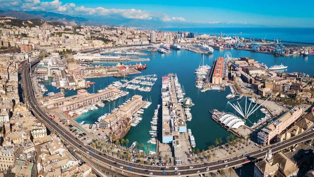

In Genoa, it happens all the time. We pass right by the city’s history without really seeing it.
We rush by on a scooter, in a car, on a bus, sometimes along the elevated road that skims the waterfront, our eyes already somewhere else. Then one day, the sun strikes a wall of stone at just the right angle, the eye stops, and we realise that the wall is neither merely a piece of infrastructure nor a leftover of the old city.
It is alive.
This is a slow piece about a vertical city: about the sea walls where the waves once broke, about a stubborn Mediterranean plant that grows in the cracks, about the longest city walls in Europe and the line of forts that crown the hills, and about the Old Port that finally gave Genoa its sea back. You can read it from your armchair, or you can use the practical section near the end to walk a good part of it yourself.
Where the sea once reached: the Mura della Marina
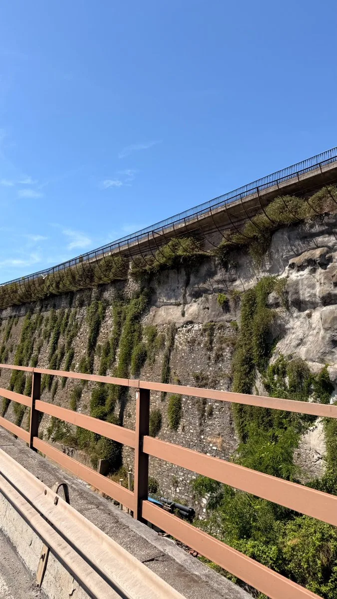
Along what is now Corso Aurelio Saffi, a stretch of the Mura della Marina is being restored. It is necessary work, and I hope it restores dignity and legibility to a place too often left in the background, almost crushed between traffic, road junctions, and habit.
These walls are not simply an urban retaining wall. They are part of the city’s old front towards the sea, even if, looking at them today from Corso Saffi or from the elevated road, that is almost impossible to imagine.
And yet the sea once reached right here.
Before the building of the Circonvallazione a Mare, the seafront boulevard, the waves broke against the rocks at the foot of the walls. The city had not yet won all that space from the water that we now take for granted, and Genoa’s relationship with the sea was far more physical, direct and rough. This stretch of walls dates from the mid-sixteenth century, when the Republic decided to fortify the section running from the marina of Sarzano down to the Porta del Molo. Then came the nineteenth century, with its hunger for expansion. In 1865 work began on the Circonvallazione a Mare: the marina of Sarzano was buried, the Campana rock vanished beneath the landfill, and a new promenade was born, facing the water and linking the Marina district with the Foce.
Later, following the line of that new road, came the Sopraelevata, the elevated motorway that is among the most argued-over and, at the same time, most identity-defining structures of modern Genoa.
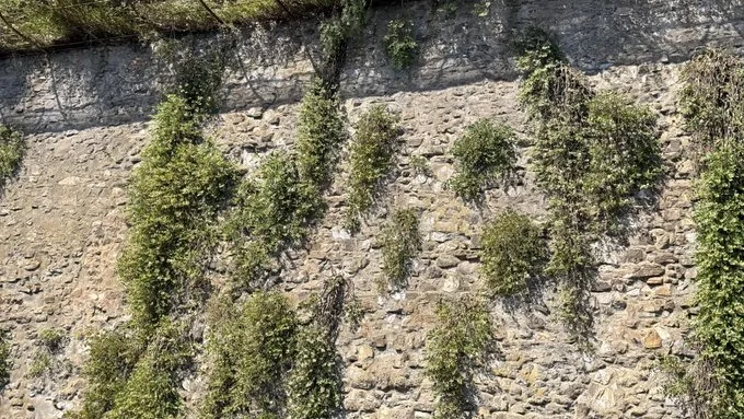
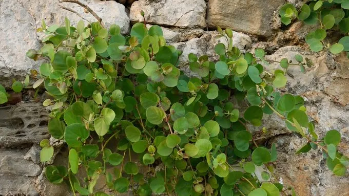
It is from up there, or passing along Corso Saffi, that you notice the caper plants clinging to the stone.
The caper: a plant that explains the Mediterranean
The caper, Capparis spinosa, is the perfect plant for understanding this coast. It loves the sun, shrugs off drought, and grows where most other plants would give up: among rocks, on cliffs, in old walls, on hot stones, in the tiniest cracks. It asks for almost nothing and yet has an enormous presence. It does not want the tidy garden. It prefers the edge, the fissure, the wall, the margin.
In that sense it is profoundly Ligurian, even though we tend to associate it above all with Sicily, with Pantelleria, Salina and the southern islands.
But the caper does not grow only in Sicily.
The Portale della Flora d’Italia, the national flora database, records Capparis spinosa in Liguria too, and even preserves a handful of local dialect names: Tapano in Genoa, Tappao in Pontedecimo, Tapni in Sarzana, Tappano in Porto Maurizio, alongside variants from the historic Ligurian area such as Menton and Nice.
I love these vernacular names, because they tell us something simple. If a plant enters the dialect, it means it has been watched, named, used, recognised. It is not a chance presence. It is part of the landscape and of material culture. In Liguria the caper does well wherever it finds stone, sun, wind and little water: on the walls of the villages, in the terraces, along certain sun-baked bands of hillside, in the cracks of old buildings. In the Cinque Terre its presence tells the same agricultural and scenic story as the dry-stone walls. Live with little, adapt to the slope, draw flavour from difficult places.
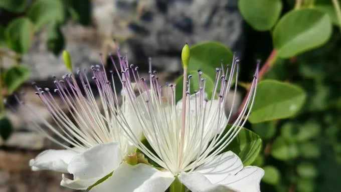
What we bring to the table as a “caper” is the still-closed bud of the flower. If it is not picked, it opens into a spectacular bloom: pale petals, almost white or faintly pink, long violet-tinged stamens, a fragile, theatrical elegance that lasts only a short while. After the flower comes the fruit, the caper berry, which in many Mediterranean kitchens is preserved and served as an aperitif or a garnish.
And here is a small marvel. What we know as a sharp, intense, almost pungent ingredient, before it becomes a jar, a sauce, a condiment or the ideal partner for anchovies, is a flower that never was. The caper is a promise harvested before it can bloom.
On the Mura della Marina, happily, many of the buds are never picked. And so the plant shows itself for what it is: one of the loveliest flowerings of the Mediterranean scrub.
In Ligurian cooking the caper rarely takes centre stage. It works in the background, like many intelligent ingredients, alongside anchovies and oily fish, olives, aromatic herbs, stuffed vegetables, cold sauces, those plain dishes that become memorable precisely thanks to one sharp, acidic note. We are used to thinking of basil, lemons, olive oil, anchovies, white wine, the herbs of the terraces. The caper stays more to the side, perhaps because we file it under a sunnier, more southern, more insular idea of Italy. And yet you only have to look at these plants on the walls of Genoa to understand that it belongs to this landscape too. If anything, it tells the story better than other, more celebrated crops, because it asks for almost nothing. It reaches out into the void and flowers exactly there, where the city would seem least hospitable.
Genoa’s walls: the longest in Europe
Step back, and the Mura della Marina turn out to be one fragment of something much bigger.
Genoa has been a city of walls since the ninth century, each ring built outwards as the port grew richer and the threats changed. The medieval gates you can still see today, such as Porta Soprana, belong to the twelfth-century circuit. In the sixteenth century, when the old walls could no longer withstand modern artillery, Andrea Doria had them modernised with bastions in the new star-fort style.
The masterpiece, though, came in the following century. Between 1626 and 1632, fearing land attacks amid the tense rivalry with Richelieu’s France, the Republic built the so-called New Walls, the Mura Nuove. They climb the hills behind the city for roughly nineteen kilometres, a high, almost invisible embrace for anyone living and moving in the streets below. They are widely described as the longest city walls in Europe and the second-longest in the world, after the Great Wall of China.
Today this whole system survives inside the Parco delle Mura, the Park of the Walls, a protected natural area of some 617 hectares that has guarded the green ridge between the Bisagno and Polcevera valleys since 2008. Strung along the New Walls is a line of forts, the real reason most walkers come up here, which I will get to shortly.
Porto Antico: the city turns back to the sea
If the Circonvallazione and the Sopraelevata are the moments when Genoa turned its back on the water, the Porto Antico, the Old Port, is the moment it turned to face it again.
For decades the historic harbour had been cut off from the centre by the elevated road, the freight railway lines and the disused industrial wharves. The turning point came in 1992, the five-hundredth anniversary of Columbus’s voyage, when the city held a Specialised Expo, “Christopher Columbus: the Ship and the Sea,” and handed the redesign to its most famous son, the Genoa-born architect Renzo Piano.
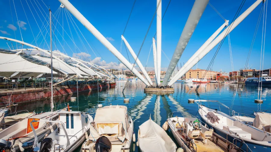
Piano’s logic was simple and quietly revolutionary: not to demolish, but to empty and reconnect. The early-twentieth-century Cotton Warehouses, two long red-brick buildings, were hollowed out and turned into public space, shops and restaurants. Alongside the restored port-archaeology buildings, the Millo, the old Customs warehouses, and the 1553 Porta Siberia by Galeazzo Alessi, he set entirely new landmarks. The Aquarium, shaped like a moored ship, remains the largest in Italy. The Bigo, a white structure with arms flung towards the sky, inspired by the bighi, the cranes that once loaded ships, features a rotating panoramic lift that rises around 40 metres for a 360-degree view of the city. Later additions followed the same spirit: the glass Biosfera, a small tropical world floating in the basin, added in 2001, and, when Genoa was European Capital of Culture in 2004, the Galata Museo del Mare in a former sixteenth-century shipyard building, complete with the Nazario Sauro submarine you can climb inside.
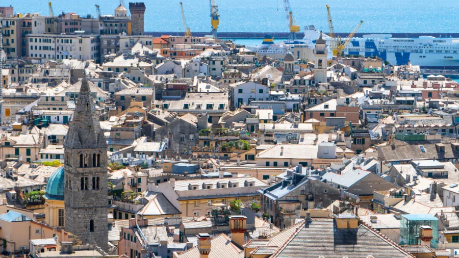
The Old Port is fully pedestrian and free to enter, and it sits at the geographic heart of the visitable city. The cathedral of San Lorenzo is a five-minute walk up into the caruggi, the famous alleys; the Lanterna, the medieval lighthouse that is the city’s symbol, is about twelve minutes west along the waterfront. It is the obvious place to stand at the bottom of Genoa’s vertical world and look up at the hills where the walls run.
Walking the forts: a practical route
Now for the climb, because the best way to understand Genoa’s walls is to walk along them.
The classic outing is the Passeggiata dei Forti, sometimes called the Ring of Forts. It does not demand a mountaineer. The paths are wide, mostly easy to moderate, and you can make the day as short or as long as you like.
Getting up there. From the centre, take the red Zecca-Righi funicular. It has been climbing since 1895, leaves from Largo della Zecca, and after about ten minutes deposits you at the Righi terminus, a panoramic terrace at roughly 292 metres with one of the best views in the city, over the rooftops, the Lanterna and the whole gulf. A single ride costs around €1.20 on the AMT vertical-transport ticket, though it is worth checking current fares. From the terminus, it is a 1.5-kilometre walk along Via Mura delle Chiappe, past the Astronomical Observatory, to the start of the trails near the Righi car park.
The forts, in order. The first you meet is Forte Castellaccio, with the Val Bisagno opening below you towards the sea. Then comes the most imposing of them all, Forte Sperone, around 490 metres, sitting astride the ridge that divides the two valleys. From Sperone you have a choice. Turn west along the sentiero delle mura, and you reach the nineteenth-century Forte Begato, around 470 metres, looking out over the Val Polcevera. Or carry on along the ridge to the small Forte Puin, then Forte Fratello Minore, and finally the prize: Forte Diamante, the highest and most isolated of the lot, at around 660 metres, reachable only on foot.
How far, how long. A there-and-back to Forte Sperone is short and almost level, with a return of around an hour, and gives you the big view for little effort. The full out-and-back to Forte Diamante from Righi is the proper outing, roughly three to four hours return, moderate, with a couple of dips and climbs but nothing alarming; families do it regularly. A looped version taking in Sperone, Puin and Diamante runs to around seven or eight kilometres.
An alternative way in. If you would rather start from above, take the narrow-gauge Genova-Casella railway from Piazza Manin and get off at the Campi (Trensasco) stop, then walk in to Forte Diamante from the northern side. It is a lovely, less-trodden approach.
A few honest tips. There is no reliable drinking water on the route, so carry plenty, especially in summer. Even in high summer the ridge can be cool and, at the forts themselves, properly windy, so pack a light windbreaker. Wear shoes with grip. And leave time at the Righi terrace at the end. There are restaurants with panoramic terraces up there, and a plate of something with a view back down over the city you have just walked above is a fine way to close the day.
What a city chooses to keep
Looking at the building site on the Mura della Marina, it is natural to wonder what will become of those caper plants.
The simplest answer is that a restoration must remove anything that could threaten the masonry’s stability. And that is true. Roots, dampness, water seeping in, and uncontrolled vegetation can be a serious problem for a historic structure. You cannot wave the question away with botanical romanticism.
But there is another, more interesting question. Is it possible to tell the difference between decay and landscape? Between an invasive weed and a presence that has become part of a place’s identity? Between what threatens the wall and what, handled with care, might be kept, recorded, even reintroduced in a controlled way?
The caper plants on the Mura della Marina were not born yesterday. Some, judging by their size, look decades old. They have become part of how we see that wall. They have clothed it, softened it, made it recognisable. On their flowering days they turn a face of stone into a spontaneous vertical garden, long before contemporary planning invented the language of green walls. I am not saying they should all be left, come what may. I am saying they should be looked at before they are removed. Studied. Photographed. Assessed. Recorded. Propagated, perhaps, and rethought within a planting scheme compatible with the restoration. Because looking after heritage should not automatically erase the living traces that time has produced. It should know how to read them.
The finest thing about the caper is that it has no need to call itself resilient. It simply is. It grows where it can, makes the most of what little it finds, flowers when the sun beats hardest, and gives us a precious ingredient and a most elegant flower. It stands in the middle of history without asking permission, and without making a sound.
On the walls of Genoa it seems almost to remind us that the Mediterranean is not only a postcard of sea and brightly coloured villages. It is also hot stone, drought, adaptation, poor man’s cooking, wild botany, dialect names, walls that once looked out at the sea, and plants that make a home where we see only a crack.
Genoa’s walls deserve to become visible again. They deserve light, care, maintenance, a story told well. But it would be good if, along with the restored stone, the city found a way not to lose those cascades of capers in flower altogether.
Because sometimes a city recognises itself in its monuments. And sometimes in a stubborn plant growing on a wall.
If you want to walk it
- Start point for the forts: Zecca-Righi funicular, from Largo della Zecca (centre) to the Righi terminus.
- Trailhead: about 1.5 km from the funicular terminus, near the Righi car park.
- Shortest taste: Righi to Forte Sperone, around 1 hour return, easy.
- Full outing: Righi to Forte Diamante, around 3 to 4 hours return, moderate.
- Bring: water (no fountains along the route), a windproof layer, and shoes with good grip.
- Down at sea level: the Mura della Marina along Corso Aurelio Saffi, and the Porto Antico, both free to wander.
Sources and further reading
- Visit Genoa, Walls and Forts
- Visit Genoa, Park of the City Walls (Parco delle Mura)
- Visit Genoa, La Passeggiata dei Forti (the forts walk)
- Renzo Piano Building Workshop, Re-development of the Genoa Old Harbour
- Bureau International des Expositions, Expo 1992 Genoa
- Portale della Flora d’Italia, entry for Capparis spinosa
Key Takeaways
- Genoa’s walls, including the Mura della Marina and the longest city walls in Europe, reflect the city’s rich history with the sea.
- The caper plant thrives along these walls, symbolising resilience and adaptability in the Ligurian landscape.
- The Porto Antico represents a revitalisation of Genoa’s connection to the sea, transformed under the vision of architect Renzo Piano.
- Visitors can explore the city’s forts through accessible trails starting from the Zecca-Righi funicular, with routes varying in distance and difficulty.
- Genoa’s unique cultural identity blends history, architecture, and local flora, making the Genoa walls and forts worth exploring.
FAQ
Yes. Genoa’s seventeenth-century New Walls (Mura Nuove), built between 1626 and 1632, run for roughly nineteen kilometres across the hills and are widely described as the longest city walls in Europe, second in the world only to the Great Wall of China. They are preserved today within the Parco delle Mura, the Park of the Walls.
Take the red Zecca-Righi funicular from Largo della Zecca up to the Righi terminus, then walk about 1.5 kilometres to the trailhead near the Righi car park. From there a well-marked path links Forte Castellaccio, Forte Sperone, Forte Puin and, highest of all, Forte Diamante.
The out-and-back from Righi to Forte Diamante takes roughly three to four hours return and is rated moderate, with a few dips and climbs but no difficult sections. The fort sits at around 660 metres and can only be reached on foot. Bring water, as there are no fountains on the route.
The Porto Antico, or Old Port, is Genoa’s redeveloped historic harbour, redesigned by architect Renzo Piano for the 1992 Columbus celebrations. It is free to enter and home to the Aquarium (the largest in Italy), the Bigo panoramic lift, the glass Biosfera and the Galata Museo del Mare.
Yes. Although capers are usually associated with Sicily, Capparis spinosa also grows wild across Liguria, including on the old walls of Genoa. It even has local dialect names such as Tapano in Genoa and Tapni in Sarzana, a sign of how long it has been part of the Ligurian landscape.
Capers flower from late spring through summer, roughly May to August, with pale white-to-pink petals and long violet stamens. The bloom lasts only a short time on each bud, so the walls of Genoa are at their most striking in the warmer months, when the buds left unpicked are allowed to open.